|
Regional Projects Include
FLLOWPA/USGS GIS Metadata Project
Assessing the Potential for Bio-Control of Eurasian Watermilfoil in New York State Lakes
State of New York Lake Ontario Basin Project
FLLOWPA/USGS GIS Metadata Project
Introduction In 1997, FLLOWPA and USGS District Office in Ithaca, New York conducted an inventory of data sources existing for all or portions of New York's Lake Ontario Basin. Data of interest are those relevant to water resources planning and analysis. The project emphasized data in digital formats (for use with a Geographic Information System, or GIs), though some data of special interest in paper formats were included in the inventory. Data sources range from federal, state, and regional authorities to local agencies and organizations. The goal of the project was to assist researchers, planners and water resources managers in assessing the availability and compatibility of existing data for use in watershed applications.
Developing a watershed database can pose challenges. Data may be housed in various agencies and organizations, often with varying use policies; data scales and formats for subunits of a watershed or for varying coverages may not be compatible. There may be gaps in data for large, multi-jurisdictional watersheds. Improving the coordination of digital data development and availability is a long-term goal of FLLOWPA. There are counties in FLLOWPA which have pioneered the development of a watershed database by collecting data from disparate sources and filling in the gaps where necessary with newly digitized data. There are many watersheds for which no such database currently exists.
Purpose
The purpose of this project was to compile and make available a list of relevant data sources for use by any group or individual interested in watershed-based mapping, planning, inventory and analyses. The listing is designed in two tiers. The first tier includes specific data coverages at federal, state and regional agencies; the second tier data sources at the local level which is either an enhancement of federal or state data or unique (not available from federal and state sources). Each list gives a data coverage name, format, and scale; hardware and software specifications; and a contact name and references for more information. FLLOWPA and USGS view this project as a preliminary step toward the development of a New York State Lake Ontario Basin digital database - a long-term product of interest and usefulness to multiple organizations.
Approach
Each FLLOWPA member representing a county participating in the project conducted an inventory of local data sources. USGS inventoried federal and state sources. Results were shared between the two organizations to check for completeness and accuracy.
Results
A final report including state and federal, state, regional, and local data sources and illustrative maps is available through the Water Resources Board. The inventory of local, state and federal sources in PDF format is available from this website below.
Local, Federal and State Data Sources for Watershed Planning and Analysis.
Assessing the Potential for Bio-Control of Eurasian Watermilfoil in New York State Lakes
Milfoil Clogs New York State Waters
Eurasian watermilfoil (Myriophyllum spicatum) is the predominant submersed aquatic plant nuisance found in ponds and lakes throughout New York State. This aggressive weed grows rapidly to the surface forming a dense canopy that clogs waterways. The canopy blocks sunlight from reaching desirable native plants that grow at a slower rate, and lose their struggle with Eurasian watermilfoil.
Failure of Mechanical Harvesting and Chemical Herbicides as Long-Term Controls Mechanical harvesting and chemical herbicides are management strategies long used in New York State to control excessive aquatic plant growth. These two methods yield little long-term success in controlling watermilfoil growth. Harvesting and chemical controls provide only annual relief at a cost of millions of dollars each year in New York State and throughout North America.
Aquatic Insects Preferentially Eat Milfoil in New York Lakes
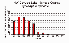
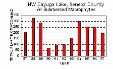
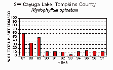
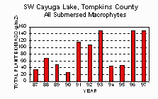
In 1991, aquatic moth caterpillars were observed eating and causing severe damage to Eurasian. The insect is the European aquatic moth, an exotic species. It is not known how long before 1991 the aquatic moth entered Cayuga lake, but biomass sampling by Cornell University Section of Ecology of Systematics from 1987-1991 showed that large areas of milfoil failed to flower at the surface. This lack of flowering and inability of milfoil to reach the water surface to form a canopy often indicates insect feeding on the growing tip of milfoil. During this time, desirable native submersed plant species took advantage of the damaged, "chewed up," milfoil and now dominate Cayuga Lake's aquatic plant community. This very diverse, stable, and healthy aquatic plant community supports increased aesthetic, recreational, and fishery uses of Cayuga Lake.
Survey Finds Aquatic Insects Feeding on Milfoil in Several New York State Lakes
FLLOWPA has cooperated with Cornell University to survey area lakes and ponds for the presence of the European aquatic moth and another invertebrate, an aquatic weevil (Euhrychiopsis lecontei), which also feeds on macrophytes. Robert Johnson or Cornell's Experimental Ponds Program has directed these surveys. Qualitative and quantitative data about the presence of these insects in area lakes were recorded (Fig. 2). Lakes in counties outside of FLLOWPA were surveyed during this period as well. The surveys report the caterpillar of the aquatic moth, Acentria ephemerella, eating milfoil in 31 of 33 New York lakes and the aquatic weevil, Euhrychiopsis lecontei eating milfoil in all surveyed lakes. The surveys further show some lakes, or areas of a lake, to have very large numbers of these insects present while other lakes have very few. Future research will try to answer why some lakes support greater numbers of these insect herbivores than others.
Recording of Aquatic Moth (Acentria ephemerella) and
Aquatic Weevil (Euhrychiopsis lecontei) in New York Lakes 1995 - 1997
| LAKE |
COUNTY |
LOCATION |
COORDINATES |
MOTH |
WEEVIL |
Burden Lake
Cayuga Lake
Cayuga Lake
Cayuga Lake
Cayuta Lake
Cazenovia Lake
Chautauqua Lake
Crooked Lake*
DeRuyter Lake*
Dryden Lake
Goodale Lake*
Jamesville Res.
Keuka Lake
Keuka Lake
Keuka Lake
Keuka Lake
Labrador Pond*
Lake Champlain
Lake George
Lake Lagrange
Lake Moraine
Lake Neatahwanta
Lake Salubria
Lamoka Lake
LeRoy Res.
Little York Lake
Oneida Lake*
Otisco Lake N.
Otisco Lake S.
Otter Lake
Owasco Lake
Panther Lake
Seneca Lake
Seneca Lake
Seneca Lake
Silver Lake
Spencer Lake*
Tully Lake S.
Tully Lake N.
Tuscarora*
Waneta Lake
Whitney Pt. Res.*
|
Rensselaer
Cayuga
Seneca
Tompkins
Schuyler
Madison
Chautauqua
Onondaga
Madison
Tompkins
Cortland
Onondaga
Steuben
Yates
Yates
Yates
Onondaga
Essex
Warren
Wyoming
Madison
Oswego
Steuben
Schuyler
Genesee
Cortland
Oneida
Onondaga
Onondaga
Cayuga
Cayuga
Oswego
Seneca
Seneca
Schuyler
Wyoming
Tioga
Cortland
Onondaga
Madison
Schuyler
Broome
|
Maple Grove
Union Springs
Seneca Falls
Ithaca
Odessa
Cazenovia
Chautauqua
Tully
DeRuyter
Dryden
Slab City
Jamesville
Hammondsport
Branchport
Brandy Bay
Penn Yan
Apulia
Willsboro
Lake George
Lagrange
Hamilton
Fulton
Bath
Tyrone
LeRoy
Little York
Shackelton Pt.
Amber
Rice Grove
Meridian
Auburn
Carterville
Geneva
Glass Factory Bay
Watkins Glen
Perry
North Spencer
Preble
Tully
Erieville
Weston
Whitney Point
|
42°36'16" N, 73°34'00" W
42°50'32" N, 76°42'07" W
42°54'12" N, 76°45'00" W
42°28'17" N, 76°31'37" W
42°21'27" N, 76°44'34" W
42°57'10" N, 75°52'30" W
44°11'32" N, 79°26'25" W
42°46'54" N, 76°09'05" W
42°49'37" N, 75°54'02" W
42°27'47" N, 76°16'20" W
42°42'22" N, 76°08'58" W
42°58'19" N, 76°04'07" W
42°24'20" N, 77°13'00" W
42°35'42" N, 77°08'46" W
42°37'35" N, 77°05'29" W
42°39'06" N, 77°04'05" W
42°46'54" N, 76°02'53" W
44°24'04" N, 73°23'52" W
43°25'42" N, 73°42'07" W
42°47'37" N, 78°00'00" W
42°51'38" N, 75°30'46" W
43°18'37" N, 76°26'00" W
42°19'46" N, 77°17'44" W
42°24'36" N, 77°04'56" W
42°53'35" N, 77°58'32" W
42°42'27" N, 76°09'08" W
43°14'20" N, 76°08'30" W
42°53'95" N, 76°18'45" W
42°50'54" N, 76°15'24" W
43°08'17" N, 76°31'54" W
42°51'32" N, 76°31'02" W
43°19'44" N, 75°54'31" W
42°52'02" N, 76°56'35" W
42°50'33" N, 76°57'49" W
42°24'35" N, 76°53'14" W
42°37'26" N, 78°01'57" W
42°15'00" N, 76°30'07" W
42°46'20" N, 76°07'57" W
42°46'54" N, 76°07'57" W
42°52'07" N, 75°45'44" W
42°25'48" N, 77°06'07" W
42°20'21" N, 75°57'54" W
|
y
y
y
y
y
y
y
y
y
y
y
y
y
y
n
n
y
y
y
y
y
y
y
y
y
y
y
y
n
n
y
n
y
y
y
y
y
y
y
y
y
y
|
y
y
n
n
y
y
y
y
y
y
y
y
y
y
y
y
y
y
y
y
y
y
y
y
y
y
?
y
n
y
y
y
y
y
n
y
y
y
y
?
y
?
|
Fig. 2 Samples collected from 42 locations in 33 lakes in 19 counties. The table shows herbivore presence with 'y' for yes or 'n' for not found. Lakes marked with an * were not part of quantitative field surveys and have a '?' entered if no herbivore was observed. A 'n' means no herbivore was recorded as being present in the lake from our sampling, but it may still be present. We sampled these lakes at least once from 1995 to 1997. |
Can Insects Limit the Growth of Milfoil in New York State?
These insects are already causing severe damage to milfoil in many New York Lakes, with the aquatic moth associated with declines of milfoil and recovery of native plants in a few lakes. A decline is defined as a decrease in milfoil growth over a number of growing seasons, and is different from a "crash" of milfoil plants within a season. The aquatic weevil is found causing damage to milfoil in all lakes surveyed, but milfoil declines associated with the weevil have not been observed in New York. Monitoring of New York lakes for long-term declines associated with these insect herbivores will continue. Paradoxically, current methods used to control the growth of milfoil in New York can be detrimental to the survival and reproduction of these beneficial insects, resulting in an increase or continuation of milfoil growth. Individuals and organizations responsible for aquatic plant management need information on these dynamics and on-going research.
For more information, contact:
Robert L. Johnson, Manager
Cornell Pond Facility Section of Ecology and Systematics
150 Corson Hall Cornell University, Ithaca, NY 14853
Phone: 607-257-2064 Fax: 607-255-8088 email: [email protected]
State of the New York Lake Ontario Basin Project
The Water Resources Board contracted with EcoLogic, LLC of Cazenovia, New York to conduct an assessment of water quality and watershed management programs and approaches in FLLOWPA’s program area – the New York State Lake Ontario Basin. The resulting report, titled The State of the New York Lake Basin: A Report on Water Resources and Local Watershed Programs was published in 2000. The report serves as a benchmark for the basin’s overall quality and local programs and efforts to address nonpoint sources of pollution.
The WRB initiated the State of the Basin project to:
- Assess water quality status in the region.
- Identify approaches to water quality problems, and describe especially successful local efforts to facilitate the transfer of good ideas in the basin.
- Assess the degree of congruence between water quality problems as identified through state data sources and local priorities and grassroots efforts to mitigate nonpoint sources of pollution within subbasins.
- Recognize the work accomplished by other organizations involved in water quality, and identify potential areas for collaboration.
- Clarify and set organizational goals for FLLOWPA.
A complete copy of State of the New York Lake Ontario Basin Project is available.
|